The resort complex was the brain child of Thaddeus Lowe, a man of many, many
talents including being head of Abraham Lincoln's "Hot Air Balloon Corp" during the
Civil War. Originally, the resort complex had four hotels, a funicular railway, miles of
hiking and horse trails, and a world-class observatory. Of course, Prof Lowe ran into
financial difficulties almost right away and the Pacific Electric Railway soon got
control. Here are some nice web sites which will do a more thorough job of expanding
your education on the subject:
http://www.mtlowe.net/
http://www.picturehistory.com/product/id/8684
http://www.mountlowe.org/
http://www.stanford.edu/~scamp/mountlowe/
http://www.mtlowe.net/brief_history.htm
http://www.pasadenahistory.org/thingstosee/MountLowe.html
http://www.erha.org/pelines/penml.htm
http://mraltadena.com/mount_lowe_rr/loweframeset.html
After after destroyed three of the four hotels, things were a little tough on the operators
and when extra-heavy rainy season of 1938 destroyed much of the right-of-way leading
up to the incline railway, the P.E. abandoned the mountain railway and scraped it out.
Unfortunately, I missed being able to ride on the wonderful mountain trollies by a
couple of decades, but I sure had fun collecting artifacts every since.
| Fast hikers can make it to the Echo Mountain ruins in about 1hour. There is no water on this loop so carry enough to last you depending on conditons - Check the Altadena Weather Cam. |
| Highlights: Fascinating historic railway, great views, pine trees, deep canyons Near: Altadena, CA (4.8 miles away) Scenery: Four Stars Distance: 11 miles round trip Elevation Gain: 2600 ft Hike Time: 6 hours Difficulty: Strenuous Trail Condition: OK, but a few difficult spots HikeType: Loop Summary: I really enjoyed this hike along the ruins of the Mt Lowe railway, Echo Mountain, and the Alpine Tavern. These locations were the most popular in Southern California in the late 1800's, before being destroyed by floods and fire. More than a dozen historical markers along the way tell the fascinating story of this railway. To top it off, the hike includes stunning views, pine forests, deep canyons, and lots of hiking. The first half of the hike, up to Alpine Tavern (now Mt Lowe Camp) and Inspiration Point, follows the Sunset Ridge Fire road to the top. The return leg is a bit more convoluted, but quite fun. A quarter mile down hill from Inspiration point, take the Sam Merrill Trail to Echo Mountain and visit the ruins of the former Inn at this location. Next head right on Echo Mountain Trail back to the Sunset Ridge Fire road. A hundred yards down the fire road on the right, take the unmarked trailhead for Sunset Ridge Trail, which parallels the fire road, and will get you home. Trailhead: From Loma Alta Drive in Altadena, drive up the Chaney Trail (past a locked gate that opens at 6am) to the top of sunset ridge, where there's parking by the roadside. The trail starts east on the gated paved sunset Ridge fire road. Source: I really enjoyed this hike along the ruins of the Mt Lowe railway, Echo Mountain, |
Los Angeles Times
Title: L.A. THEN AND NOW
'Railway to the Clouds'
Captured the Imagination of
California
Date: June 9, 2002
In the decades known as the
"Great Hiking Era," from the
1890s to the 1930s, a visionary
and avid hiker built a "Railway to
the Clouds"--which for a time
Title: L.A. THEN AND NOW
'Railway to the Clouds'
Captured the Imagination of
California
Date: June 9, 2002
In the decades known as the
"Great Hiking Era," from the
1890s to the 1930s, a visionary
and avid hiker built a "Railway to
the Clouds"--which for a time

| If you enjoy our quizzes, don't forget to order our books! Click here. |
| If you have a picture you'd like us to feature a picture in a future quiz, please email it to us at CFitzp@aol.com. If we use it, you will receive a free analysis of your picture. You will also receive a free Forensic Genealogy CD or a 10% discount towards the purchase of the Forensic Genealogy book. |

| Quiz #164 Results |

| ********** |
| Answers: 34°12′40″N 118°07′16″W Inspiration Point, near Mt. Lowe and Echo Mountain, north of Altadena, CA |
| ********** |
| Answer to Quiz #164 - June 22, 2008 |
| ********** |
I don't know but my orientation of the signs made me think the viewing of the
tourists was from a west to east look at the coast with San Pedro being North of
Venice and LA.Oh well. Can't win em all. I concede a loss cause "I don't need no
HINTS" I coulda been a contenda. LOL "Marlon Brando: On the Waterfront".
Jim Kiser
*****
I spent a lot of time out on a tangent trying to find a site that had all the location signs
to see what the missing one was and which ?Arm the Arm sign on the far right was
pointing to and I found the ?ARM, it was OSTRICH FARM! Good challenging quiz!
Fred Stuart
*****
I grew up in Pasadena, so this is a pretty familiar locale. Tom Pincince
*****
Well thank goodness for Google Maps and Wikimapia! I was a little confused by the
difference between Echo Mountain and Mt. Lowe - most of the time they were used
almost interchangably. I'm from Northern California so I'd never been to either. I've
only been to a few Southern California mountain ranges.
The hint was really useful for that one! I knew it was California but there are a number
of mountains in Southern California to have to go through. I was searching on
"observation point" still didn't get much. I was so relieved when there was a hint.
These are so fun! Teresa Yu
*****
I’d read about the 5 Inspiration Points also. I had some problems with this quiz before
the hint – I did several searches for overlooks and views and looked at info about
almost all of the parks around L.A. One that was a contender for this location due to
how old the park is and because it has those overlook telescopes behind it was Griffith
Observatory in Griffith Park. Tonight, my wife and I saw a showing of “Rebel
Without a Cause” which takes place largely around and in Griffith Observatory.
Brian Kemp
| Thanks to Tom Davis for suggesting this quiz. |
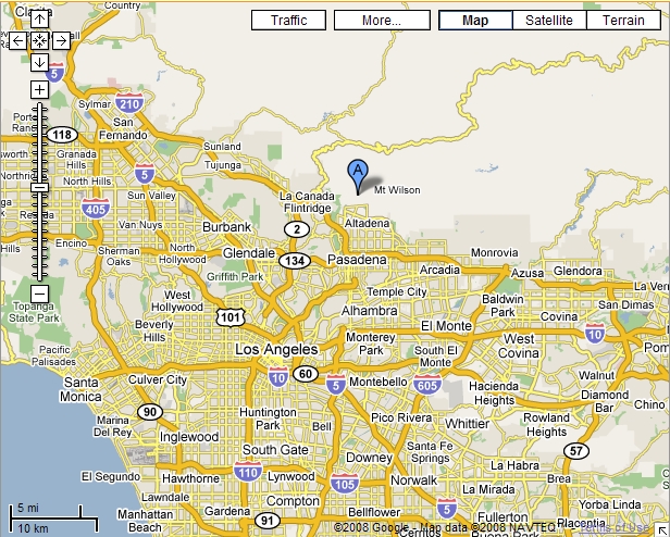
| Mount Lowe Railway Loop http://maps.google.com/maps... |
| How The Quizmasters Solved the Puzzle |
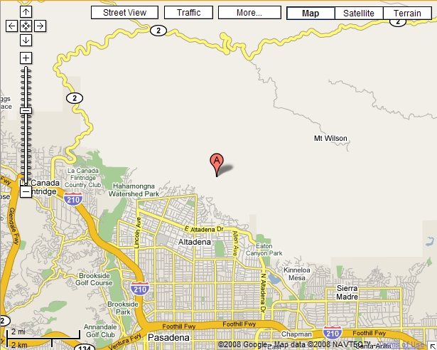
| Location of Echo Mountain http://maps.google.com/maps... |
| Foothill Flyers Mountain Trail Runs Echo Mountain Inspiration Point Altadena Sam Merrill and Castle Canyon Trails |
| Beth Long |
| Andy Hoh |
| Note skyscrapers of LA in center of viewing tube www.flickr.com/photos... |
Well, first I typed in Venice, Los Angeles and San Pedro, and saw they were all in CA.
It was obvious that the persons in the photo were using telescopes or some type of
viewmaster to see these sites, and when I used to do this as a kid at various tourist
spots, they were always called "look out" points.
So, I looked for lookout points in CA and came up with one of the results being
Lookout Point Park. I then checked Mapquest to see where these cities were located in
relation to each other, and since they were sort of a triangle of three points, I knew the
location couldn't be in the center, as all the telescope were facing one way for those
cities.
I then saw Catalina which worked with the telescope direction, but didn't see any
references to a current or old tourist lookout point being there in Avalon (not even
realizing as you point out that the telescopes were in the wrong order! Duh!!) :) I
kept trying to find some type of result that would say something like "and from this
point you can see Venice, Los Angeles, SanPedro, etc." but never found anything like
that except for references on heavy smog, and on a clear day you might be able to
see.... etc.
So, I then got the coordinates for Lookout Point, saw it on the map, it seemed to work,
so I submitted that before the hint came out. ;) I was hoping to find more history of
Lookout Point, old photos, etc. so I could be more sure of the answer but I didn't find
much, so hopefully the full answer on Sunday will give more detail.
At first I thought it was maybe something like the Hollywood sign location or maybe
the Mulholland Drive Overlook, so went through lots of Google pics to see if I could
find early pictures of those locations. Then work reared its ugly head (I work as an
economist at a law firm (I'm also a lawyer, but the economic side is much more fun) -
and I had to track down info on some shady company in Puerto Rico that someone is
suiing - I have the rep as the "research guy of last resort" around here - anybody has
some off-the-wall research needs doing, they call me - so you can see why I find your
contests so much fun)
But that sort of cleared my head to take another look at the puzzle. I decided to Google
"locating Los Angeles" and on the 2d page of results came across "StacyK's
photostream" site on Flickr http://flickr.com/photos/stacyk/page2/ which if you search
again for "locating Los Angeles" within that site (StacyK has some very cool pictures,
btw), shows a very familiar looking, but current, picture of the site, taken in June 2007,
with the identification "Inspiration Point". From there it took a bit more research to find
which Inspiration Point it was (there are 5 in Los Angeles County, as I'm sure you
know) and then learn all about Mt Lowe and the railway and Ye Olde Alpine Tavern etc
(some of *those* pics are a hoot!) - and then some more current pics of what
Inspiration Point looks like today, etc., etc.
As always, a fun and informative contest.
| ********** |
| Views of Inspiration Point |
| Congratulations to Our Winners! Mike Dalton Martha Lasser Carolyn Cornelius Rex Cornelius Andy Hoh Beth Long Beverly Johns Gary Sterne Erica Augustine Stan Read Judy Pfaff Sharon Martin Pinky Palladino Janessa Roberts Claudio Trapote Fred Stuart Sharon Martin Karen Petrus John Chulick Don Draper Justin Campoli Diane Burkett Beth Tafel Wayne Douglas Barbara Battles Tom Tollesen Pat Thomas Jim Kiser Dennis Brann Rhonda Hensley Evan Hindman Bob Mackenna Karen Petrus Karen Kay Bunting Dave Doucette Janis Tomko Bob Wilson Cheri Black Rex Cornelius Carolyn Cornelius Beverly Johns Mike Dalton |
| Beth Tafel |
Your first clue was the one that did it for me. I figured that it had to be a place with
"inspiration" in its name and went looking for an "Inspiration Point". A really nice
website at www.modernhiker.com turned up some great photographs, including a
modern day photo of the "finding tubes" that are still there. Discovering that this
particular Inspiration Point was near Echo Mountain, all I had to do then was to google
coordinates of Inspiration Point (cross-referenced with coordinates of Echo Mountain)
and found them at www.mountainzone.com.
Replica of an "echophone" mounted
over the edge of Castle Canyon for
visitors' use. The few of the
echophones that still exist are parts of
personal or museum collections.
http://upload.wikimedia.org/wikipedia/en/1/15/Echo_phone.jpg
over the edge of Castle Canyon for
visitors' use. The few of the
echophones that still exist are parts of
personal or museum collections.
http://upload.wikimedia.org/wikipedia/en/1/15/Echo_phone.jpg
| Inspiration Point Pavillion Note viewing tube seen in pavillion. http://www.spannertech.com/biking... |
| Google Earth Map of Echo Mountain (near Inspiration Point), Palo Verde, Venice, and Los Angeles |
| ********** |
| View up Castle Canyon of the Inspiration Point Pavillion from the Echo Mountain Resort ruins. This Pavillion is 1.8 miles from Echo Mountain at an elevation of 4,520'. Photo by Bob Dollins,2/28/2004 hikertechnologies.com/echmtn_inspirpt_pavillion.htm |
| Another view of the pavillion. www.flickr.com/photos/infanteus/429614656/ |
| Mount Lowe Railway |
| View of Los Angeles from Inspiration Point at Night http://www.thaddeuslowe.name/MLAlpinebeyond.htm |
| ********** |
| The One Man One Mule Railroad http://mraltadena.com/mount_lowe_rr/ch16.html |
became Los Angeles' foremost amusement ride.
Thaddeus Sobieski Constantine Lowe and a partner conceived the world's first
electric-powered mountain railway, the Mt. Lowe Scenic Railway above Altadena,
which was considered one of the world's greatest engineering feats of the 19th century.
They carved out a wonderland of hotels, a zoo, an observatory, a grand pavilion, a
searchlight that played on the valley below and trails in the San Gabriel Mountains. The
| Mount Lowe Railway Loop |
seven-mile railroad traversed severe mountain
slopes and transported millions of sightseers
willing to pay as much as $5 each round trip. For
four decades, it was Southern California's leading
tourist attraction. But fire, flood, an earthquake, a
rockslide, the Great Depression and the decline of
rail transit led to its demise.
The railway idea began in 1888 when Lowe, a
gifted scientist and devoted family man, moved
from New Hampshire to Pasadena with intentions
of retiring at age 55. He built a
24,000-square-foot showplace on Orange Grove
Boulevard, where he dreamed and gazed longingly
at the snow-capped peak of Mt. Wilson.
He had served the Union forces as a
reconnaissance balloonist for President Lincoln
during the Civil War. Demonstrating the value of
the balloon, he took the first aerial photographs
| ********** |
| Comments from Our Readers |
and pioneered aerial mapping.
Despite only a fourth-grade education, he made a fortune from inventions and patents
dealing with steel, hydrogen gas and refrigeration. He also helped organize two banks.
Read more....
Despite only a fourth-grade education, he made a fortune from inventions and patents
dealing with steel, hydrogen gas and refrigeration. He also helped organize two banks.
Read more....


| 1. What are the GPS coordinates of this location? 2. What is its name? Hint #1: We hope that this quiz will serve as an inspiration to our readers. Hint #2: Search in the area near Mount Wilson. |


| ********** |


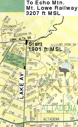
| The start is from the very top of Lake Av in Pasadena. From the 210 take the Lake Av off ramp and go north toward the mountains til you cant go any farther (at Loma Alta Dr,). Park on Lake Av. or Loma Alta. Thomas Map 536-A3-4. If you plan to run this trail on the weekend, parking can be sparce and if the case, consider parking at Farnsworth Park. The trailhead is at the NE corner of Lake and Loma Alta. Run east about 100 yards along the fence until you come to the trail sign and a drinking fountain. From there you will go NE down into a little valley and up the other side to the start of the switchbacks. 2.7 miles from Lake Ave up the Sam Merrill Trail, you will come to the top and a trail junction. From there you will go south on the old Mt. Lowe Railway bed about 100 yards, past the upper Sam Merrill Trail and Castle Canyon trail junction and you should see the large cable car gear at the ruins. Read more... |
| More Photos of Inspiration Point As it was and as it is Click here. |
| ********* |
| ********** |
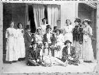
| Notes from Tom Davis, Contributor of This Week's Quiz Photo |